
Location: Canyonlands National Park is located in Southeastern Utah. The park is divided into three districts. The Island in the Sky District is the northern most district. The Visitor Center is about 40 minutes from Moab, Utah and 25 minutes from Dead Horse Point State Park.
Cost: $10 per vehicle. First come first serve campsites are available for $10.00. There are also fees of up to $30 for back country permits.
Operating Seasons and Hours: The park is open all day every day. Visitor Center hours usually are from 9:00 to 4:00, but it is open longer in the summer. The Visitor Center is closed from late December through February.
Official Website: http://www.nps.gov/cany/planyourvisit/islandinthesky.htm
Date of Visit: Wednesday, May 19, 2010.
This was the third stop of the sixth day of the Southern Utah Road Trip that my husband and I went on for our third anniversary in May of 2010. We left Dead Horse Point State Park, and drove about 11 miles to the Island in the Sky District of Canyonlands National Park.
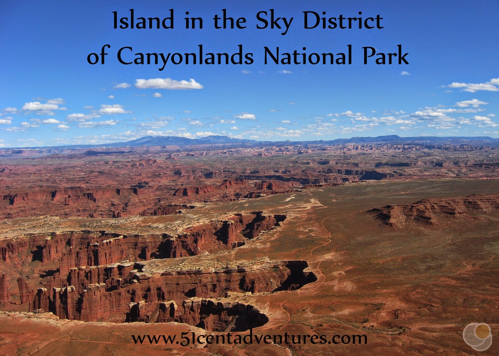
Before I get too far into this post we need to stop and talk about the way Canyonlands National Park is laid out. Canyonlands is a huge park made up of lots of sandstone. That sandstone has been shaped by erosion from wind and rain, freezing and thawing cycles, and from the rivers that flow through the park. The Green River and the Colorado River converge in the middle of the park. They divide the park into three sections or district.
There aren't any roads that go over the rivers to connect the districts. That means that it is near impossible to visit all three districts in one trip. In theory you could drive from district to district using the roads that go around the park, but that can take up to 6 hours. In most cases you are probably going to have to just pick one district to visit.
Let's talk about each district for a second.
The Island in the Sky District is the northernmost district. It is located between the Green and Colorado Rivers. It is the most easily accessible district and has many features that are within short hiking distances. Most of the district sits atop a large mesa and so there are soaring vistas just about every way you look. The visitor center is about a 50 mile drive from Moab, Utah.
The Needles District is located on the eastern side of the park. The Colorado River forms it's western boundary. There are many trails that take you through the tall sandstone pillars and spires that give the Needles it's name. Most features require you to hike to see them. The visitor center for this area is about a 75 mile drive from Moab, Utah.
The Maze District is located on the western side of the park. The Green and Colorado Rivers form it's eastern boundary. The Maze is the most remote district of the park. The only roads into the park are dirt roads that pretty much require 4 wheel drive. The district is accessible from the west near Goblin Valley. It is a 134 mile drive from Moab, Utah to the Hans Flat Ranger Station at the edge of the Maze District. From there there is another 27 miles to the Maze Overlook Campground. Don't think that those 27 miles will go quickly. You'll have to travel slow on the dirt road so the drive will take between 2 to 3 hours. Basically don't try to plan a "quick trip" to the Maze District. Only go there if you have the time and resources to spend days in the park.
My husband and I picked The Island and the Sky district as the one we wanted to explore on this roadtrip. Looking back, we probably could have also worked in a stop in the Needles District. But we opted out of doing that for some reason that I can no longer remember. I guess we liked how close Island in the Sky was to Dead Horse Point State Park.
Earlier in the day, when we'd been at the overlook inside Dead Horse Point State Park, I had experienced what I thought was a miscarriage of my 11 week twin pregnancy. My husband and I debated ending our trip, or at least going to the hospital in Moab to get me checked out. But we decided that we'd rather just keep going on our vacation. In our minds there was no way an emergency room doctor could help us out so we might as well finish our vacation. What we didn't know was that I hadn't really had a miscarriage. It would be 6 weeks before we discovered that I was still pregnant (and that I'm really out of tune with what my body tries to tell me.)
Of course we didn't know that at the time. What we did know was that we were less than 15 miles from Canyonlands. It seemed like such a waste to be so close and not go check it out. I was feeling relatively fine so we decided to at least drive into the park and visit a scenic overlook. While we were driving my husband turned to me and said something like, "I don't want to be sad anymore, lets go on a hike."
We consulted the trail guide that was part of the park map we received when we entered the park. The obvious choice was to hike to one of the best known features of the park, Mesa Arch. It was a half a mile round trip with only a 100 foot elevation change. However, we didn't pick that hike. We were planning on spending the next two days in Arches National Park and so Mesa Arch didn't sound like a unique enough feature.
Since Mesa Arch is one of the park's signature features I thought you would still want to see some pictures of it. These two photos were taken by my friend Audrey. In addition to being an outdoors lover, Audrey also maintains the only food blog I read on a regular basis. Check out her work over at www.dirtydishclub.com.


Instead of the hike to Mesa Arch we chose the hike to the Upheaval Dome. I think we planned to hike to the first overlook which would have only been an .8 of a mile round trip, but once we got there we continued on another half mile to the second overlook. I usually walked four miles a day so this mile and a half hike really wasn't too long of a distance for me. Still when I look at this picture I can't believe I was doing this only a few hours after what I thought was a miscarriage. This probably should have been my first clue that things were not as bad as I thought they were.

Check out how the Upheaval Dome looks on Google maps.
This is what the Upheaval Dome looks like from the trail. It's is such an odd looking feature.

The trail to the Upheaval Dome gave us some great panoramic views of the surrounding landscape. We could even see a small arch off in the distance.


Overall I wish that I had been feeling better during this trip to Canyonlands National Park. I feel like I would have been able to experience and remember so much more about the park. However, I am glad that I did go there and see the few things that I did.
Directions: The Island In the Sky District of Canyonlands is located to the southwest of Moab. However, the only road to this part of the park is located to the north of Moab. You reach the park by travelling north on Highway 191 for about 15 miles. Then you turn left onto State Road 313 and stay on that for another 18 miles. State Road 313 travels to the south west. There will be a split in the road. The right fork will take you to the Island in the Sky District of Canyonlands, the left fork will take you to Dead Horse Point State Park. There are signs all along the way, so really it's not that complicated.
Additional Information: There are many videos about Canyonlands National Park available at http://www.nps.gov/cany/learn/photosmultimedia/multimedia.htm. These videos cover a wide range of topics including descriptions of how the area formed, animals that live in the area, and things to see when you visit the park.
Places Nearby: I've mentioned Dead Horse Point State Park a lot in this post. Both areas are very similar but there are differences between them. For an in-depth comparison of the parks check out my post titled: Island in the Sky District of Canyonlands National Park vs Dead Horse Point State Park.
One day I want to plan a trip to ride the rapids on the Cataract Canyon section of the Colorado River. This famous section of white water rapids are located inside Canyonlands National Park. Read this for more information about Cataract Canyon http://www.nps.gov/cany/planyourvisit/cataractcanyon.htm.
The rapids are very difficult so it's a good idea to go with a guide. There are several businesses in Moab who provide everything you need, including a guide, for a trip through Cataract Canyon. You can find a business here http://www.discovermoab.com/tour.htm
Next Stop: Arches National Park
Love Canyonlands! Thanks for the shoutout.
ReplyDelete